We cover all kind of tour package including hotel booking and pilgrimage tours.
Welcome to
DiscoverUttarakhand
A Heartiest welcome to the tour & travel
world of Discover Uttarakhand. We offer you specially customized packages
for almost all exciting destinations of Uttarakhand. Having a wide
travel network, we offer the most hospitable service and assure you of a
most memorable trip
Tour Packages
..............................
Char Dham Yatra
Lake side View Tour
Corbett Tour
Himalayan Tour
Garhwal Tour
Kumaun Tour
Delhi Pick and Drop
Lucknow Pick and Drop
Dehradun Pick and Drop
..............................
Char Dham Yatra
Lake side View Tour
Corbett Tour
Himalayan Tour
Garhwal Tour
Kumaun Tour
Delhi Pick and Drop
Lucknow Pick and Drop
Dehradun Pick and Drop
Book Hotel and Tour Packages in uttarakhand
Pl. call +91-9058913568,+91-9506913481,
mail all deatils :suresh.himalaya1988@gmail.com
mail all deatils :suresh.himalaya1988@gmail.com
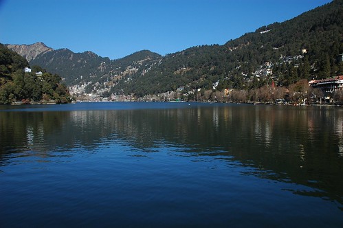
Nainital-
Nainital (नैनीताल) pronunciation (help·info) is a popular hill station in the Indian state of Uttarakhand and headquarters of Nainital district in the Kumaon foothills of the outer Himalayas.
Situated at an altitude of 2,084 metres (6,837 ft) above sea level,
Nainital is set in a valley containing a pear-shaped lake, approximately
two miles in circumference, and surrounded by mountains, of which the
highest are Naina (2,615 m (8,579 ft)) on the north, Deopatha (2,438 m
(7,999 ft)) on the west, and Ayarpatha (2,278 m (7,474 ft)) on the
south. From the tops of the higher peaks, "magnificent views can be
obtained of the vast plain to the south, or of the mass of tangled
ridges lying north, bounded by the great snowy range which forms the
central axis of the Himalayas.".
pronunciation (help·info) is a popular hill station in the Indian state of Uttarakhand and headquarters of Nainital district in the Kumaon foothills of the outer Himalayas.
Situated at an altitude of 2,084 metres (6,837 ft) above sea level,
Nainital is set in a valley containing a pear-shaped lake, approximately
two miles in circumference, and surrounded by mountains, of which the
highest are Naina (2,615 m (8,579 ft)) on the north, Deopatha (2,438 m
(7,999 ft)) on the west, and Ayarpatha (2,278 m (7,474 ft)) on the
south. From the tops of the higher peaks, "magnificent views can be
obtained of the vast plain to the south, or of the mass of tangled
ridges lying north, bounded by the great snowy range which forms the
central axis of the Himalayas.".
| Climate data for Nainital |
|---|
| Month | Jan | Feb | Mar | Apr | May | Jun | Jul | Aug | Sep | Oct | Nov | Dec | Year | ||||||||||||||||||||||||||||||||||||||||||||||||||||||||
|---|---|---|---|---|---|---|---|---|---|---|---|---|---|---|---|---|---|---|---|---|---|---|---|---|---|---|---|---|---|---|---|---|---|---|---|---|---|---|---|---|---|---|---|---|---|---|---|---|---|---|---|---|---|---|---|---|---|---|---|---|---|---|---|---|---|---|---|---|---|
| Average high °C (°F) | 9.4 (48.9) |
11.2 (52.2) |
15.5 (59.9) |
19.9 (67.8) |
23.2 (73.8) |
22.9 (73.2) |
20.1 (68.2) |
19.6 (67.3) |
19.3 (66.7) |
18 (64) |
15.4 (59.7) |
12.4 (54.3) |
17.24 (63) |
||||||||||||||||||||||||||||||||||||||||||||||||||||||||
| Daily mean °C (°F) | 5.2 (41.4) |
6.8 (44.2) |
10.6 (51.1) |
15 (59) |
18.2 (64.8) |
18.6 (65.5) |
17.2 (63) |
16.8 (62.2) |
15.9 (60.6) |
13.6 (56.5) |
10.6 (51.1) |
7.8 (46) |
13.03 (55.45) |
||||||||||||||||||||||||||||||||||||||||||||||||||||||||
| Average low °C (°F) | 1.1 (34) |
2.4 (36.3) |
5.7 (42.3) |
10.1 (50.2) |
13.3 (55.9) |
14.4 (57.9) |
14.3 (57.7) |
14 (57) |
12.6 (54.7) |
9.3 (48.7) |
5.9 (42.6) |
3.2 (37.8) |
8.86 (47.92) |
||||||||||||||||||||||||||||||||||||||||||||||||||||||||
| Precipitation mm (inches) | 64 (2.52) |
56 (2.2) |
60 (2.36) |
35 (1.38) |
67 (2.64) |
178 (7.01) |
443 (17.44) |
381 (15) |
241 (9.49) |
76 (2.99) |
8 (0.31) |
27 (1.06) |
1,636 (64.4) |
||||||||||||||||||||||||||||||||||||||||||||||||||||||||
| Source: Climate-Data.org | |||||||||||||||||||||||||||||||||||||||||||||||||||||||||||||||||||||
Mythology

It is believed that Nainital figures in some ancient myths of India. In the Manas Khand of the Skand Puranas, Nainital Lake is called Tri-Rishi-Sarovar, hinting at the story of three sages (or rishis),
Atri, Pulastya and Pulaha, who, upon finding no water in Nainital, dug a
large hole at the location of the present day lake (sarovar = lake) and filled it with water from the holy lake Manasarovar in Tibet. According to lore, a dip in Naini Lake, "the lesser Manasarovar," earns merit equal to a dip in the great lake.

1880
The Kumaon Hills came under British rule after the Anglo-Nepalese War (1814–16), but the hill station town of Naini Tal was founded only in 1841, with the construction of the first European house (Pilgrim Lodge) by P. Barron, a sugar trader from Shahjahanpur. In his memoir, he wrote: "It is by far the best site I have witnessed in the course of a 1,500 miles (2,400 km) trek in the Himalayas

A general view of the north end of Naini Tal before and after the Landslip of 1880.In September 1880 a landslide (the Landslip of 1880)
occurred at the north end of the town, burying 151 people. The first
known landslide had occurred in 1866, and in 1879 there was a larger one
at the same spot, Alma Hill, but "the great slip occurred in the following year, on Saturday 18 September 1880."
"Two days preceding the slip there was heavy rain, ... 20 inches
(510 mm) to 35 in (890 mm) fell during the 40 hours ending on Saturday
morning, and the downpour still lasted and continued for hours after the
slip.
Transition

TennisTournament
Nainital,1899
Nainital,1899
Tourism
Nainital Lake- Also known as Naini Lake, it is situated in the heart of the city and it is owing to this lake that Nainital earned its name. The eye-shaped lake is a tourist hotspot and acts as a magnet for all those visiting the hill resort. Here, a person can either take a leisurely stroll or indulge in boating and enjoy the surrounding beauty. The northern end of the lake is called Mallital, while the southern one is called Tallital. The Lake Bridge that connects the two banks has quite a few shops as well as a post office, the only one in the world to be located on a bridge.
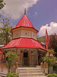
Naina Devi Temple- The temple is located on the northern shore of Naini lake. The presiding deity of the temple is Maa Naina Devi represented by two Netras or eyes. Flanking Naina Devi are the deities of Mata Kali and Lord Ganesha. Nainital is believed to be one of the 64 Shaktipeeths, where one of the body parts of Goddess Sati fell, when Lord Shiva carried her body. In Nainital, the eyes (naina) of the Goddess are assumed to have fallen. The shrine of Naina Devi is a must visit for devout Hindus. and was reconstructed after being destroyed in the 1880 landslide. One can also get an amazing view of the hill station, overlooking the lake, from the temple.
St. John in the Wilderness, a church established in 1844 and is located on the north end of town (Mallital), about half a mile north-west of the Naina Devi temple. The church was so named by Daniel Wilson, the Bishop of Calcutta, who, after falling ill during a visit to Nainital in 1844 to lay the foundation of the church, was obliged to sleep in an unfinished house on the edge of the forest. (See excerpt from Josiah Bateman on the Literary references to Nainital page.) A brass plaque on the altar is inscribed with names of the victims of the Landslip of 1880.
Governor's House also known Raj Bhavan and formerly, Government House was built in 1899 and designed in the Victorian Gothic domestic style (also called "domestic Gothic") by the architect F.W. Stevens. Originally built as the summer residence of the governor of the North West Province, it later became the summer residence for the Lieutenant Governor of the United Provinces. Currently, Raj Bhavan is the official guest house for the governor of Uttarakhand and for visiting state guests. The complex consists of a two-storied mansion with 113 rooms, a large garden, a swimming pool, and golf links. Obtaining prior permission is a "must" for visiting.

Naini Peak also known as China or Cheena Peak or Naina Peak is the highest peak in the town, with an altitude of 2,615 m (8,579 ft). and at a walking distance of 6 km (3.7 mi) from the north end of the town (Mallital). From atop the peak, one can not only see a broad swath of the snow clad high Himalaya, but also obtain a panoramic view of Nainital town itself. The summit is an invigorating hike from Nainital town; in addition, for the less energetic visitors, ponies can be hired in Mallital or on Snow View and the Great Wall of China Tiffin Top also known as Dorothy's Seat This terraced hill top (2,292 m (7,520 ft)) on Ayarpatta hill is a 4 km (2.5 mi) hike from the town centre and commands a nice view of the neighbouring country side. Dorothy's Seat is a stonework picnic perch on Tiffin Top built as a memorial to a British Army Officer's wife, Dorothy Kellet, by her husband Col J.P. Kellett DSO MC, City of London Regiment, and admirers after her death from septicaemia aboard a ship bound for England to be with her 4 children, Elizabeth, Joan, Barbara and Richard. She was buried at sea in The Red Sea in 1936.
The High Court of Uttarakhand building formerly known as the 'Old Secretariat', when Nainital was the summer capital of United Provinces.

Gurney House, the former residence, of Jim Corbett, is located on Ayarpatta Hill. Before leaving for Kenya, Jim and his sister Maggie sold the house to a zamindari family in Bihar. It is a private residence but is open to visitors as a museum of Corbett memorabilia.
Eco Cave Gardens is a natural garden which is situated just next to Kumaon University Campus. It is just 1 km away from Sukhatal and 2 km from Mallital. It has six caves along with a musical fountain.[11]
Others: Laria Kanta, Land's End and Sukhatal. The surrounding hillside is rich with deodar, oak, pine and rhododendron.
Places near Nainital

Mukteshwar (2,286 m (7,500 ft)) is a picturesque town 52 km (32 mi) north-east of Nainital, is home to the Indian Veterinary Research Institute. It also offers an unhindered view of the high mountains of the western Himalaya, including Nanda Devi, Trisul, and Nanda Kot.
Bhimtal Lake – Situated 22 km from the city center, Bhimtal Lake is the biggest lake of Nainital. It is named after the second Pandava brother Bhima in the Mahābhārata who was known for his prodigious strength. The lake, which is larger than Naini Lake, is approximately 22 km (14 mi) from Nainital at an altitude of 1,370 m (4,490 ft). There is an island in the lake with a popular restaurant on it. There is also a 17th-century temple complex, the Bhimeshwar, alongside a 40 ft (12 m) high dam at one end of the lake.
Sattal, literally Seven Lakes, is at a distance of about 23 km (14 mi) from Nainital in the Lower Himalayan Range at an altitude of 1,370 m (4,490 ft). It is a cluster of small interconnected lakes in the midst of an old oak forest. On approaching Sattal, the first lake encountered is the Nal-Damyanti Lake; next it is the Panna or Garude lake; and finally there is a cluster of three lakes: Ram, Laxman, and Sita lakes.
Khurpa Tal, literally Trowel Lake, is an attractive lake about 10 km (6.2 mi) by road (or a 5 km (3.1 mi) hike) from Nainital at an altitude of 1,635 m (5,364 ft). It is popular with anglers and is surrounded by terraced fields (or farms), from which it presumably gets its name.

Hanumangarhi, also known as Hanuman Garh, is located at an altitude 1,951 m (6,401 ft). The temple complex is about 3.5 km (2.2 mi) from the Tallital (South End) bus stop. The presiding deity of the temple is Lord Hanuman, the vanara god of the Ramayana, and he is depicted tearing open his chest to reveal Rama and Sita in his heart. It is connected saint Neem Karoli Baba, who had his ashram at Kainchi. Hanuman Garhi is also known for its spectacular views of the setting sun.
Pangot – a popular bird watching and camping spot, close by.
Mahesh khan FRH-Mahesh khan is near Bhowali, bhowali is 40 km from haldwani or 10 km from Nainital you can contact at forest range office at bhowali for booking .it is situated in quite and dense forest and this FRH is recently renovated.
Ghorakhal- Ghorakhal is the place situated in the Nainital district of the Uttarakhand state of India. Ghorakhal means pond for water to horses. It is the picturesque site at the height of more than 2000 mts. This place is famous for the temple of Lord Golu which is worshiped by the hill people.[12] It is situated near Bhowali and is the seat for Army school, known as Sainik School Ghorakhal, established in 1966 at the Ghorakhal Estate of the Nawab of Rampur. The famous Golu Devta temple is situated on a hill above overlooking the school
No comments:
Post a Comment